
Row, row, row your boat gently up / down the stream???
Purpose: This blog post is created to help readers a) better understand electronic compass [smartphone or rangefinder] residual azimuth deviation errors b) quantify the errors, c) model the errors, d) compensate for [correct] the errors, and e) influence the app vendors to apply the correction method within their own affected smartphone app. Basically, we need to know (accurately) whether to go up / down the stream (path) we are traveling on.
Goal: The goals of this blog post are to prove a) the usefulness of an accurate smartphone compass app for practical applications, b) the manufacturer’s recommended calibration procedures work just fine to address/correct errors due to magnetic influences within the phone itself, c) residual [after calibration] smartphone compass deviation errors exist due to external/environmental magnetic influences beyond the reach of the calibration procedures, and d) residual compass azimuth deviation errors can be corrected [effectively compensated] to provide “just-good-enough” compass azimuth accuracies sufficient to “get-the-job-done” – in all but the most demanding circumstances.
Background:
This post a) introduces and b) presents test results of a new Android / TruPath Compass app (prototype/beta version) operated at three very different (geographically dispersed) test sites. The iOS version of TruPath Compass will follow shortly. TruPath Compass is the ONLY smartphone compass app that compensates (corrects) residual azimuth deviation errors – at this time.
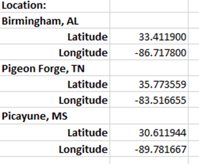
- Birmingham, AL test site has a strong magnetic/ electromagnetic fields influencing the earth’s magnetic field.
- Pigeon Forge, TN test site is in mountainous terrain without any known environmental magnetic influences. The Pigeon Forge test site is approximately 306 miles northeast of the Birmingham, AL test site.
- Picayune, MS test site does not exhibit any known environmental magnetic influences. The Picayune, MS test site is approximately 264 miles southwest of the Birmingham, AL test site.
The data collection equipment and procedures used for all three (3) test sites were identical to those used at the original Birmingham, AL test site (and others) for all prior posts. Refer to the original post/page at http://www.tru-path.org.
- True North (reference direction) was established based on the sun position (azimuth) relative to the test site’s geographic location on the date/time of the test – a correct, defendable, and independent reference direction.
- The Android/TruPath Compass app was set to indicate azimuths relative to True North.
- The Android phone (sensors) were re-calibrated prior to each test.
- Only the “portrait” phone orientation was used for these three test sites.
- Recall: Residual (after calibration) compass deviation error persists throughout the entire 360 degree range of measurement.
Test Sites and Practical Application Descriptions
Birmingham, AL
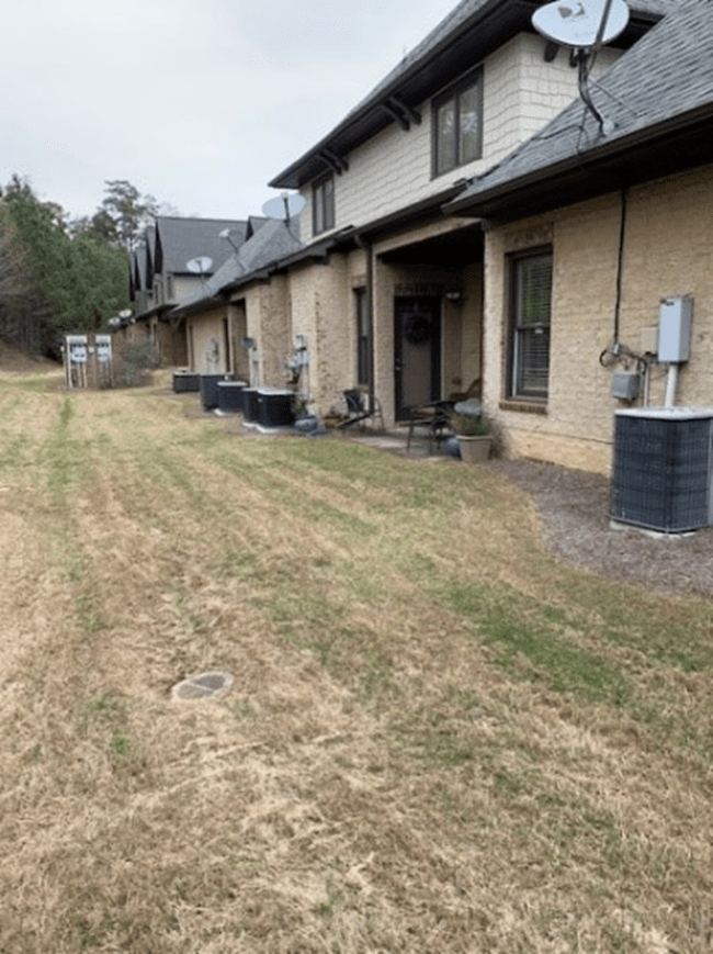
The Birmingham, AL test site is set in an urban environment with strong magnetic/electromagnetic influences including:
- An electric power distribution station for eight (8) townhomes
- At least eight operating heating/cooling (heat pump) units of 3 to 4 ton capacity – aligned North/South within 50 feet of the test site (East side)
- An active highway – aligned North/South within 150 feet of the test site (West side)
The application at the Birmingham test site involved a “compass survey” to locate a leaking underground water pipe (irrigation/sprinkler) system. Refer to the following two (2) photos.
Contractor instructions were derived from existing maps/sketches/documents.
- Beginning at a first point 3 ½ feet north of the northwest corner of building 10 and aligned (at the northwest corner of building 10) with the rear (western) edge of Building 10,
- Proceed 81 feet in a direction of 242 SW (degrees) to locate a second corner point in the existing underground water (irrigation/sprinkler) system.
- From the first point, proceed in a direction of 242 SW (degrees) for a distance of approximately 15 feet to a third point – within the wet area of the leak.
- The leak should be within a 10 foot circle centered at the third point.
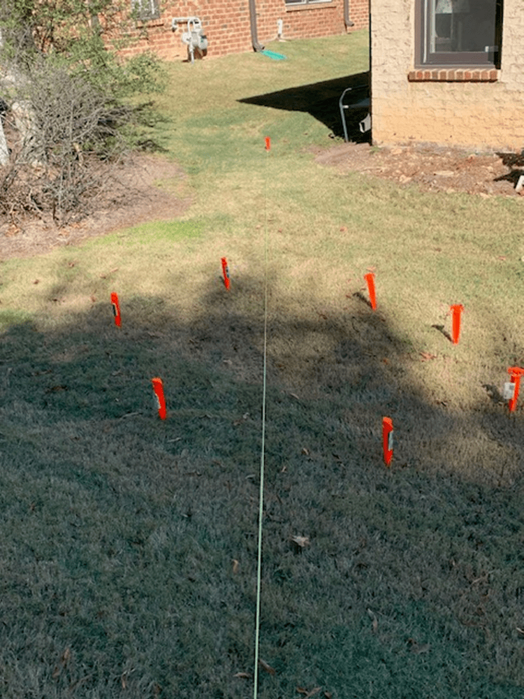
Picayune, MS
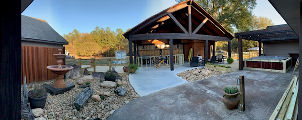
The Picayune, MS test site (new construction) is set in a rural (single-family dwelling) environment with limited magnetic/electromagnetic influences including:
- Electric power for a single-family dwelling approaching from the opposite (southern) side of a ranch-type construction of about 2100 square feet.
- A four (4) ton air conditioning unit exists on the opposite (southern) side of the structure – at least 150 feet away from the test site.
- No automotive vehicles were located within 200 feet of the construction area – the site of the new outdoor (open air) kitchen and entertainment center shown in the photograph above.
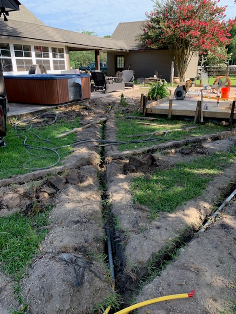
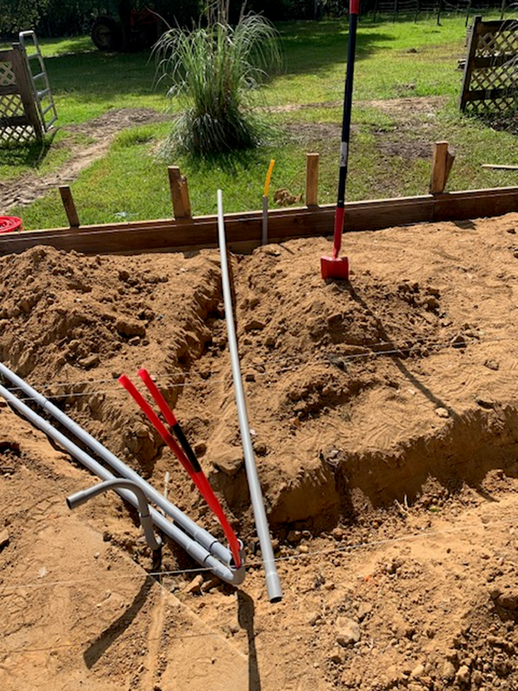
The application at the Picayune test site reproduced a “compass survey” to locate/map underground utilities (water, gas, and electric) used to support kitchen and surrounding garden features shown in the photograph above – fountain, hot tub, fire pit, and kitchen appliances. Refer to the following two (2) construction photos.
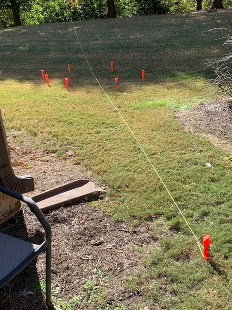
Pigeon Forge, TN

The Pigeon Forge, TN test site is set in a rugged, rural (Smoky Mountains) environment with no known magnetic/electromagnetic influences.
- No electric power.
- No air conditioning units exists.
- No automotive vehicles were located within 1,000 feet of the test site area. The test site is a hiking area as shown in the photograph above.
The application at the Pigeon Forge test site involved personal navigation along a hiking trail using a smartphone (Android) with the TruPath Compass app (prototype) installed.
Test Results
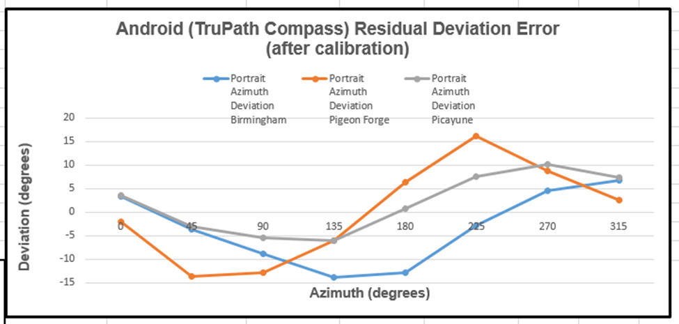
The following data table presents the collected azimuth data (yellow) and the associated residual deviation error (orange) for one Android phone orientation (portrait). The residual compass deviation error data was collected in the same manner as all the other error data presented in this blog series.
Notes:
- The data collected for the Birmingham test site was collected using a tripod – a steady platform for the data collection operation.
- The data collected for the Picayune test site was collected with the smartphone being handheld – a realistic mode of operation at a construction site.
- The data collected for the Pigeon Forge test site was collected using a tripod – a steady platform for the author’s 11 year old granddaughter who performed the data collection operations. This test demonstrated the ease-of-use of the TruPath Compass software.
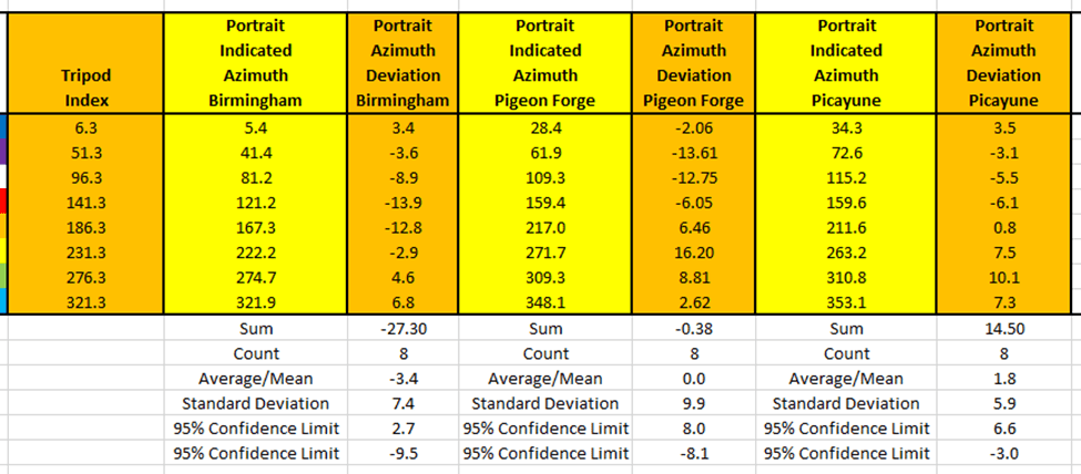
The Android/TruPath Compass app had done its best – yet residual (after calibration) azimuth deviation (error) persisted in each test site scenario.
The following chart depicts the residual azimuth deviation (error) measured at each individual test site.
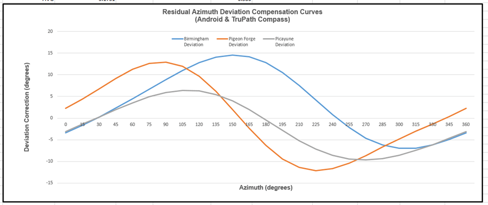
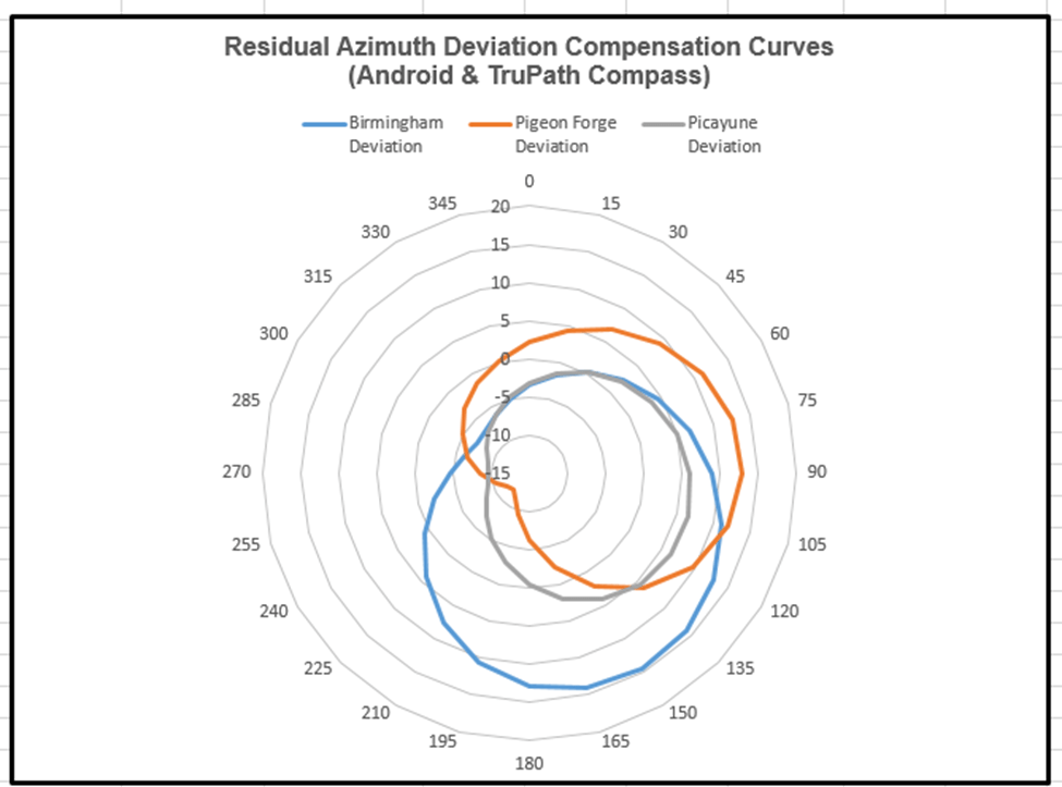
The “modeled” deviation curves (derived from the residual deviation error) for the Android/TruPath Compass app are presented below. The modeled residual azimuth deviation compensation curves are presented in two different formats to allow the reader to seriously consider the deviation error (magnitude & direction) – as measured throughout the full 360 degree range of measurement.
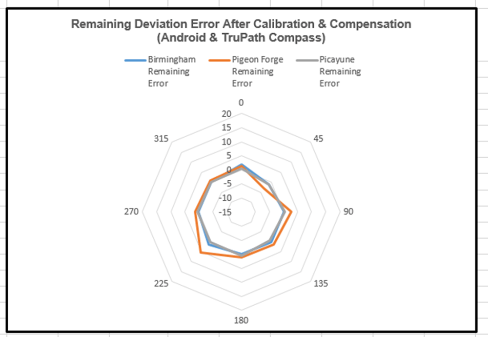
The compensated deviation errors (remaining azimuth errors after compensation) for the Android & TruPath Compass app are depicted below. Again, two display formats are provided to strengthen the perceived impact of the compensation method.

The predicted and the measured residual azimuth deviation errors for the Android & TruPath Compass app are depicted in the following chart. The predicted error curve is the negative of the deviation curve; and the compensation method proved quite effective.
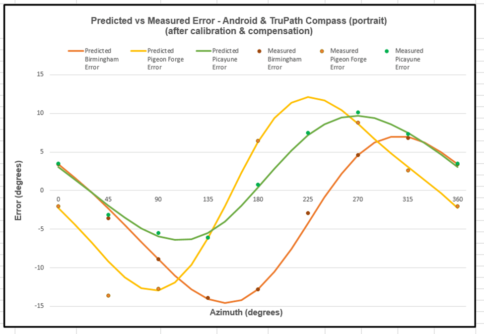
Note: The second measured point for the Pigeon Forge data involves (apparently) a user data collection error.
Conclusions:
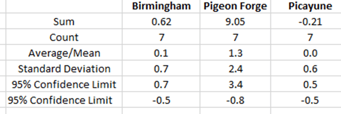
- The Android/TruPath Compass app indicates the following measured residual (after calibration) azimuth deviation error ranges – 95% confidence limit for each test site.
- Birmingham: -9.5 < Residual Deviation Azimuth Error < +2.7 (degrees)
- Pigeon Forge -8.1 < Residual Deviation Azimuth Error < +8.0 (degrees)
- Picayune -3.0 < Residual Deviation Azimuth Error < +6.6 (degrees)
- The compensated Android/TruPath Compass app results indicate the following remaining error ranges (after correction), within a 95% confidence limit.
- Birmingham: -0.5< Residual Deviation Azimuth Error < +0.7 (degrees)
- Pigeon Forge -0.8 < Residual Deviation Azimuth Error < +3.4 (degrees)
- Picayune: -0.5< Residual Deviation Azimuth Error < +0.5 -(degrees)
- The Android/TruPath Compass app is easy-to-use in either handheld or tripod-mounted data collection methods.
- The TruPath Compass app (prototype) required about 4 minutes to collect the measured azimuth readings for each test case – very efficient.
- The TruPath Compass app (prototype) can be effectively used by the author’s 11 year old granddaughter – and older individuals.
- The TruPath Compass app (prototype) can be used to compensate residual (after calibration) azimuth deviation errors in a very effective manner – over a wide range of geographic locations.
- The TruPath Compass app (prototype) makes the smartphone “compass survey” method plausible.
- The TruPath Compass app (once released) will be capable of:
- Compensating residual (after calibration) azimuth deviation errors on the host smartphone.
- Determining the necessary compensation parameters for any third-party smartphone compass app; and these compensation parameters will be available for correcting the third-party compass app’s residual azimuth deviation errors – if the third-party vendor elects to do so.
- Determining the necessary compensation parameters for any third-party rangefinder compass; and these compensation parameters will be available for correcting the third-party rangefinder compass residual azimuth deviation errors – if the third-party vendor elects to do so.
- Determining the necessary compensation parameters for any third-party electronic compass; and these compensation parameters will be available for correcting the third-party electronic compass residual azimuth deviation errors – if the third-party vendor elects to do so.
Preview: In upcoming blog posts, we will deal with other Android/iPhone compass apps. As with previous tests involving the Android/iPhone compass apps, the same methods will be used to collect, analyze, and present the results.
The next blog post is planned to deal with the Android/TruPath Compass app – compensating residual azimuth deviation errors in the middle of a crowded auto parking lot with lots of magnetic/electromagnetic influences.

Leave a comment